19 November 2012

Sianok canyon , Would Fall in Love at First Sight

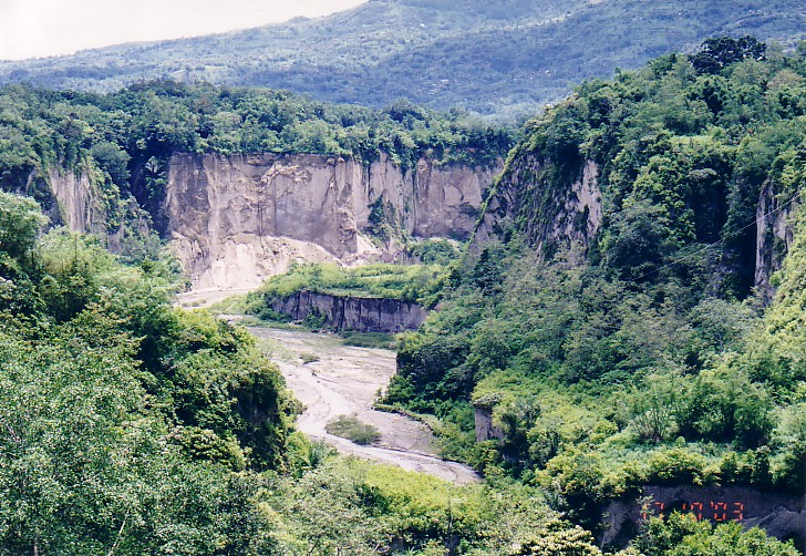
The natural beauty is one of the traveling purposes. There is one place that has a beauty that never runs out and always make anyone wonder. The place was named canyon Sianok in Bukittinggi, West Sumatra.

If eastern Indonesia has a fascinating underwater world, then in the western part has a green landscape nan charming. For you lovers of nature, come to the canyon Sianok. His charm will hypnotize you.

From its name, the valley and the canyon has meant Sianok is the name of a village in the forging. Located not far from the Clock Tower near the center of Bukittinggi. You can take public transportation or take Bendi, local traditional vehicles such as horse cart in Yogya.

You can see a perfect view of the canyon Sianok from Panorama Park. Simply pay Rp 5,000 only, in the garden there is also a famous Japanese hole. The garden is very beautiful and spacious, cool weather was a typical Dublin will make the atmosphere a favor.

From there, you can see a perfect landscape. This valley has cliffs covered by green forests. The extent of the up to tens of kilometers, will make unceasing admiration!

Throughout the eye could see, the valley is very charming. On the left side there is a barren cliffs and forests and small streams. On the right, there are rice fields, roads, and houses. Still not satisfied? The top there if fog-covered mountain.

Prepare your camera because the scenery is hard to find anywhere else. Guaranteed you will never be satisfied pictured in this valley. Do not forget to explore the souvenir shop nearby. There are plenty of souvenirs in the form of T-shirts that read Bukittinggi, accessories, miniatures to the Clock Tower.

The place was pretty crowded on weekends. In addition, there is also a herd of monkeys around the park. No need to be afraid because the monkey is pretty tame on the visitors.

Source Article  : Here
Source Picture : Here

18 November 2012

Prambanan Temple, Cultural Heritage of Indonesia 's Biggest Hindu

Prambanan is incredibly beautiful building built in the 10th century during the reign of two kings, and Rakai Rakai Pikatan Balitung. Towering 47 meters (5 meters higher than Borobudur temple), the foundation of this temple has fulfilled the desire to show Hindu triumph in Java Island. The temple is located 17 kilometers from the city center, among an area that now functions as beautiful park.

There is a legend that Javanese people always tell about this temple. Once, a man named Bondowoso Jonggrang love. Because of his love, Jonggrang asked Bondowoso make 1000 temples with statues in one night. The request was nearly fulfilled Jonggrang asked the villagers to pound rice and make a big fire that created an atmosphere like the morning. Bondowoso who only completed 999 statues cursed Jonggrang into the statue-1000 because he felt cheated.

Prambanan temple has three main temples in the primary yard, namely Vishnu, Brahma and Shiva. The three temples are a symbol of Trimurti in Hindu belief. The three temples were facing east. Each main temple has accompanying temple facing to the west, namely Nandini for Shiva, Swan to Brahma, and Garuda for Vishnu. In addition, there are two temples wedge, 4 color temples and 4 corner temples. In the second there are 224 temples.

Entering the Shiva temple located in the middle and the highest building, you will find a room 4. One main room contains Shiva statue, while the other 3 rooms each containing a statue of Durga (Shiva's wife), Agastya (Shiva's teacher), and Ganesha (Shiva's son). Durga is touted as the statue of Roro Jonggrang described in the legend above.

In the Vishnu temple is located in the north of Shiva temple, you will only see one room containing a statue of Vishnu. Brahma temple is located south of Shiva temple, you will only find one room with a statue of Brahma.

Quite attractive accompanying temple is Garuda temple that is located near the Vishnu temple. This temple keeps a story of half-bird human being named Garuda. Garuda is a mystical bird in Hindu mythology, who was gold, white face, red wings, beak and wings like eagles. It is estimated, the figure is Hindu adaptation of Bennu (means 'rises' or 'shining', usually associated with the god Re) in ancient Egyptian mythology or Phoenix in Old Greek mythology. Garuda succeeded in saving his mother from the curse of Aruna (Garuda's handicapped brother) by stealing Tirta Amrita (holy water of the gods).

The ability to save that which was admired by many people until now and used for various purposes. Indonesia used it to sign the country. It is said that Garuda Pancasila symbol creator for inspiration in this temple. Other countries also use it to sign the country is Thailand, with the same reason but adaptation forms and different appearance. In Thailand, Garuda is known as Krut or Pha Krut.

Prambanan also has panels of relief describing the story of Ramayana. According to experts, the relief is similar to the Ramayana story is revealed through oral traditions. Another interesting relief is Kalpataru tree that the Hindu religion is considered as a tree of life, sustainability and environmental compatibility. In Prambanan, relief Kalpataru tree depicted lions flanking. The existence of this tree makes experts consider that the people of the 9th century had wisdom to manage its environment.

Just as the figure of Garuda, Kalpataru is now also used for various purposes. In Indonesia, Kalpataru became a symbol of Forum for Environment (Walhi). In fact, some scientists in Bali to develop the concept of Tri Hita Karana for environment conservation by seeing Kalpataru relief in this temple. The tree of life was also found in the mountains that used to open the puppet arts. A proof that the relief panels in Prambanan has worldwide.

If careful, you can also see various birds relief, this time a real bird. Bird reliefs at Prambanan are so natural that biologists can identify their genus. One was relief of the Yellow-crested Cockatoo (Cacatua sulphurea) that invite questions. Why, the bird was actually found only Masakambing Island, an island in the Java Sea. Then, what kind it was once abundant in Yogyakarta? The answer please find out for yourself. Because, until now no single person who can solve the mystery.

Source Article  : Here
Source Picture : Here

17 November 2012

Wakatobi, A Piece of Heaven on Earth


Did you know that Indonesia has the one of the most beautiful underwater paradise on earth? Underwater paradise knew as the Wakatobi National Park is located in Wakatobi, Southeast Sulawesi, Indonesia. Wakatobi is the capital of Wangi-Wangi.


Wakatobi consists of four major islands, namely Wangiwangi, Kalidupa, Tomia, and Binongko. So, Wakatobi is an acronym for the name of the four main islands. Before December 18, 2003, these islands are called Junior Iron Islands and is still a part of Buton.

Astronomically, Wakatobi located south of the equator, and like other regions in Indonesia, Wakatobi has the two seasons, rainy and dry seasons. Wakatobi National Park established in 1996, with a total area of ??1.39 million hectares, involving marine biodiversity and coral which occupies one of the highest priority position of marine conservation in Indonesia.

The beauty and richness of the Wakatobi National Park is already well known abroad, especially after Wallacea expedition from England in 1995 which mentions that the region of Southeast Sulawesi is very rich in coral species.


There, there are 750 of the total 850 species of coral in the world. Configuring the depth varies from flat to sloping to the sea, and in some areas there are bertubir steep waters. The deepest waters reaching 1044 meters.

Marine tourism is a tourist activity has long been recognized and is the mainstay of tourism in the Wakatobi National Park. The wealth of marine life is not because coral reefs along the vast waters of the underwater topography colorful as slop shape, flat, drop-off, atoll and underwater cave.

More than 112 species of corals from 13 families including Acropora formosa, A. Hyacinthus, Psammocora profundasafla, Pavona cactus, Leptoseris yabei, Fungia molucensis, Lobophyllia robusta, Merulina ampliata, Platygyra versifora, Euphyllia glabrescens, Tubastraea frondes, Stylophora pistillata, Sarcophyton throchelliophorum who live in harmony with other underwater inhabitants.

Fish species richness national park is owned by 93 species of fish including (Cephalopholus argus), takhasang (Naso unicornis), pogo-pogo (Balistoides viridescens), napoleon (Cheilinus undulatus), red fish (Lutjanus biguttatus), rabbitfish (Siganus guttatus) , Amphiprion melanopus, Chaetodon specullum, Chelmon rostratus, Heniochus acuminatus, Lutjanus monostigma, Caesio caerularea, and others.

Wakatobi National Park is also a point of some kind of sea birds such as goose-brown stone (Sula leucogaster plotus), Malay plover (Charadrius peronii) and King Prawn Eurasia (Alcedo atthis) nested.

Several species of turtles also make this park their home as hawksbill (Eretmochelys imbricata), loggerhead turtle (Caretta caretta), and fission turtle (Lepidochelys olivacea).
Wakatobi waters have loyal guests who make Wakatobi waters as a playground, a guest was none other than the sperm whale (Physeter macrocephalus). Normally, sperm whales are in Wakatobi in November, while the other hemisphere freezes. In the relatively warmer waters of Wakatobi and abundant feed the whales could be filling the stomach.

Not only that Wakatobi is also a place to play manta rays (Manta ray) were classified as giant body size. Manta is one of the distinctive and unique fish, which is only found in tropical waters.
The presence of 25 pieces of coral reef and depth that makes the waters ideal Park Authority ideal place for various species of marine life to live, make the inhabitants of the sea here has aesthetic value and high conservation.

Specifically Park Authority surrounded coast of coral islands along the 600 miles along the beach attractions with huge potential to run, spread throughout the Wakatobi region. So it was not without reason that the beach area in Wakatobi is perfect for sightseeing as diving, snorkeling, swimming and fishing.


Source Article  : Here
Source Picture : Here

16 November 2012

GWK, Will Be the Tallest Statue in the World

There are plenty of places to enjoy the sunset in Bali, one of them was at Garuda Wisnu Kencana or pedestal. Here, you can watch the sunset from a height of 263 meters above sea level with a handsome statue of Lord Vishnu.

Only ten minutes from Ngurah Rai Airport, 25 minutes from Kuta and 20 minutes from Nusa Dua, you will arrive at the GWK. It covers an area of ??240 hectares and in this place will be built tallest statue in the world to defeat the Statue of Liberty. Nuance partial Bali you can see from this place.

GWK has the feel of a cool, all-green landscape. Not only that, the architecture and sculptures by artists of Bali you can see there. Carvings etched into the walls and sculptures shaped, providing for your own story.

One of the famous sculpture is beautiful and the size of the statue of Lord Vishnu. Sculpture is what will be the tallest statue in the world. This statue has a height of 20 meters, to form part of the way Lord Vishnu sleeveless. Later this statue will have a height 150 meters high and 64 meters wide.

In this place you can also watch the beautiful sunset. From a height of 263 meters above sea level, you can see the sun set with a serene. Occasionally you can also see that the plane will land at Ngurah Rai. In addition, Vishnu Plaza, one part in the GWK, often Balinese dance performances are held, such as Barong and Kecak dance.

On the pedestal there are also many souvenirs shops. You can hunt for souvenirs typical of Bali are beautiful and antique. If hungry, eat some homes provide a variety of foods to fill up your energy.

Sights and attractions in the GWK will rob your heart. Not only that, but the pedestal will be a symbol to protect and keep universe with its statue of the god Vishnu. When the long holiday to Bali this time, visit to GWK. Its the beauty of Bali from a different side.

Source Article  : Here
Source Picture : Here

15 November 2012

Mount Rinjani , the Palace Goddess Anjani

United Nations headquarters in New York, set the year 2002 as the year "Ecotourism, International Volcano, and Cultural Heritage". The main themes that carried it was right in the midst of environmental damage, which is bad for human life. In Indonesia, President Megawati responded with a declaration of Ecotourism In 2002, the inaugural Summit held in Selo, Boyolali, precisely at the crack of Mount Merapi-Merbabu. This reflects the concern of the national movement for environmental sustainability tourism world.

Simply put, ecotourism often called ecotourism is a tourism product that utilizes natural and environmental assets wisely. So the richness and biodiversity can be sustainable and harmonious with the surrounding human communities.

The government's decision to promote ecotourism in Indonesia is an appropriate step. This is based on the fact that the base strength of tourism in Indonesia lies in the grace of the natural wealth that stretched from Sabang to Merauke. By having 129 or 13% of the volcano volcanoes in the world, prospects for the development of ecotourism in Indonesia arguably brighter. Unfortunately, few volcanic areas managed ecotourism generating foreign exchange. More abandoned and badly damaged due to mismanagement and illegal logging.

One of the volcanoes in Indonesia, which is famous all over the world are Rinjani. Every year, there are thousands of foreign and domestic tourists up the mountain altitude 3726 m asl (above sea level) is. Inevitably, Mount Rinjani be sought after wild adventure lovers.

Located in the northern land of Lombok, West Nusa Tenggara, Mount Rinjani is the third highest volcano in Indonesia. The height of the peak is only surpassed by Jayawijaya Mountains in the Papua and Mount Kerinci who are in the land of Sumatra. There are several hiking trails that are often used to climb Gunung Rinjani. But for those adventurers who first visited Lombok, it is advisable to choose the path Sembalun Lawang. Post start climbing on this route is relatively inexpensive and easy to reach by public transport.

From the seaport gates Sheet, en route to the bus terminal in the city of Mataram. In the terminal available vehicle elf-Aikmel Mataram majors. Approximately 1 hour drive, arrived in the region Aikmel. Here, the adventurous elf greeted vehicle heading straight to climb Sembalun Lawang.

During the trip, we passed the tropical forests plus the attraction of wild monkeys on the curb. Plantation cabbage, peppers and onions stretched. Moreover, the presented views of green canyons inhabited enchanting traditional Sasak tribe, tribal Lombok. Arriving at the post Sembalun Lawang climbing, climbers must register. Prior to departure, the official rangers give a message to keep clean and respect the customs of the locals. Not forgetting also described the location of hidden springs.

For those in need, available services guide (the guide) or porter (personnel carrier), which has rental equipment and supplies standard mountaineering. The management of travel services involving this Sasak tribe, different rates apply for foreign and local tourists.


Climbing terrain

The initial challenge that must be taken is the vast plains and rolling hills. Characteristics of this nature provide a new experience for adventurers who used to climb mountains in the land of Java. Usually mountain in Java more forest presents a homogeneous and heterogeneous.

Dusty barren land with a stinging climate makes stamina quickly depleted. Only in some places lies the dense reeds rumut as delicious food for the oxen shepherd. In certain places there is a special post that can be used with a spring camping and emergency toilet. After savannas, field trip was getting heavier. Steep hill to start yawning chasm exists between heterogeneous forest hedge. Mount Rinjani can be said safely from the threat of wild animals. Birds, monkeys and chickens hanging woods that are often encountered in the woods.

After traveling about 7 hours, arrived at pelawangan (mountain ridge) Sembalun Lawang. What is overgrown with mountain pine (Casuarina junghuniana) is heading towards the final climb before the summit. Pelawangan Sembalun Lawang is located right on the slopes of Lake Segara Anakan buffer. As a result, while resting, climbers can watch unlimited exotic giant lake formed by volcanic eruption of Mount Rinjani.

Unfortunately the weather at this altitude is very volatile. Attacks can come suddenly blurred cold weather replaces the summer heat. Quite often winds capable of ripping even fly tent. However, the charm of sunrise and sunset becomes an unforgettable moment for life.

So there are two options: continue the adventure to the top of or directly down to the lake Segara Anakan. Field trip to the top heavy and quite dangerous. Deserts, craters, and seemingly bottomless abyss, will force berpacunya adrenaline for 3-5 hour drive. While field trips to Lake Segara Anakan no less thrilling. The climber must be nimble down the rocky slope with a slope ranging from 40-80 degrees. Which should be noted is that the risk of life-threatening debris rock climber.

Lake Segara Anakan

For ethnic Sasak, Lake Segara Anakan considered a sacred place that must be maintained purity. Green and blue lakes, it is also used as a place of pilgrimage and worship of Hindus, Muslims Wettu Telu (Hindu-Muslim syncretism) and belief in God Almighty. So do not be surprised, if the smoke smell incense or find a flower offerings around the lake. Moreover, the very reverence Sasak Dewi Anjani's funeral, which was believed to be the supreme ruler of Mount Rinjani is supernatural.

Water lakes that taste rough, due to a mixture of fresh water and sulfur water is believed to be a potent drug to cure various diseases. Believe it or not, in fact, this situation led to the growth of local wisdom to preserve the environment and prevent the exploitation of natural resources.

Apart from all that, the climbers will feel pampered nature. For relaxes tense muscles, we can soak in some hot water all day natural sulfur pool. Although dozens of wild monkey sex shows are toothed. The most fun, of course, burn the fish in the lake. Carp, tilapia and large-sized harper thrived in this lake. If less expert fishing or being unlucky, we can buy fish from local anglers that frequently appear in the holiday season. Across the lake looks dune dunes are often issued white smoke into the sky. People refer to it as the New Mount. Not much information about the dunes are still active.

Source Images : This

14 November 2012

Carstenz, the Only Tropical Glaciers in Indonesia

Papua natural exotica is not inexhaustible. There are still many mysteries of the beauty of the island at the eastern end of Indonesia. Call it the Raja Ampat islands are no less great, with many relics of history and beauty of the ecosystem. Of the seas in the Raja Ampat kepualaun, save a lot of beauty to be researched and unique traditions of the community again dijelajahi.Belum papuan higga already famous abroad. Species of beautiful feathered birds of paradise, only in Irian Jaya or Papua. Red fruit, are efficacious for treating various penytakit, there are also there. The beauty of the archipelago is second to none.

Indonesia should be proud of the uniqueness and richness of nature and tradition masayarakatnya. One is Carstensz Pyramid or commonly referred to as peak jaya, also in Papua. If you are a true adventurer would not have missed this glorious adventure at the peak, the Carstensz Peak is the highest peak in Australia and Oceania. Why not in Asia? Because of Asia's highest peak Mount Everest was held by existing on the border of India and China, Carstensz Pyramid Peak has altitude 4884 m above sea level (16,023 ft). Location is at the coordinates 04 ° 04 733 S and E 137 ° 09 572. Carstensz Pyramid, or Puncak Jaya called by some people, and Puncak Jaya Jaya Kesuma or mentioned only Kesuma by others, located in the west central highland called a Sudirman Jayawijaya and mountains. And the only tropical glaciers in Indonesia, which most likely will soon disappear due to global warming.

Cartensz name is taken from the inventor of a Dutch sailor, John Carstensz, who witnessed the peak of the mountain is covered by ice at the equator. In 1623 Carstensz preach the snow mountain on the equator, but no one believes her statement was. John Carstensz is the first European summit Cartensz witnessed with his own eyes.


Source Images : This


13 November 2012

Lake Toba, the Largest Lake in South East Asia

World famous Crater Lake lake (Lake) Toba is the third largest tourist destination in Indonesia. Island in the Great Lakes, Samosir Island, attract many tourists. Lake Toba is the largest lake in Southeast Asia, as created by the eruption of less than 100,000 years ago. The eruption was about 8,000 times more powerful than Mount St. Helen's eruption in 1981. Ash in the stratosphere around the earth for many years, and climate change. As things began to settle another volcanic eruption that occurred about 25,000 years later and build a secondary volcano in the caldera. Volcanic cone collapse and form the island of Samosir while the first eruption craters filled with water, what is Lake Toba.

Lake covers about 1265 square kilometers including Samosir and 90 km long. Depth is on average 450m and up to 900m in some places. The lake is located at an altitude of 906 m above sea level. Steep shorelines interspersed with small valleys creating fantastic scenery and remote areas. End of the deepest and highest mountains in the northeast end of it. The Dutchman HN van der Tuuk was the first European who saw and reported on the lake, in 1847.

Of course there are legends about how Lake Toba was formed. Here is a Toba Batak legend: Once upon a time there was a man who lived in the area of ??Lake Toba day now. No one knows when or where it comes from. He lived in a simple hut in a farming area. He had a garden and do some fishing. One day he caught a big fish in a trap. It is the biggest catch ever in his life. Back to the fish house turned into a beautiful princess adorned with jewels. He fell in love with her and proposed. He nodded romantic, however, the princess had one condition. The man had to promise not to tell anyone that he had been fishing. If he wanted to, there would be a disaster. They married and had a daughter and lived happily. My daughter always bring lunch to his father in the fields. She was however very greedy, and one day he ate all his lunch. His father was angry and scolded: "You damned son of a fish!" The princess began to cry when she heard what her husband said. He told his daughter to go to the hill, because there will be a disaster. When my daughter had left for the safety of women praying. Soon there was an earthquake, the rain began to fall and the spring appeared everywhere. The whole area got flooded and became Toba Lake. The princess turned into a fish again and the father became the island of Samosir.

According to legend Simalungun, Causeway told in the Kingdom, there was a mountain called Mount Tuhaweoba in areas where Lake Toba now. (Tuhaweoba is also the name of the type of pepper). Once upon a time the mountain exploded, Lake Toba formed and the people who shared. Those on the west side of the lake into Batak Toba Batak and on the east side Simalungun. The Tuhaweoba word change from time to time for Tuba and then to Toba.
Kano traditional Batak, solution, is 10-15m long. All have the same width. Kano from the head adorned with carvings. The captain, chief, sat in the front and give orders. The solution has a spirit of its own and when a new canoe was built offerings were made to both the spirit canoe and Boru Saniang Naga, the Goddess of Water. Batak feared him as a disaster can easily happen when he is angry.

Three years ago Lake Toba reached the lowest water level ever, which causes problems, such as for tourism. Rate it then fell a few feet and the lake is a scenic little sad for people who have seen it before. The reason for the falling water levels are deforestation and the water consumption by the pulp mill and hydroelectric plant near Porsea. Water companies consumed more than the capacity of Lake Toba is allowed. After protests and sometimes violence from local communities, pulp mills, Indorayon, closed. Protests based on different interests and concerns, among other concerns of course the environment. The water level, however, is also controlled by the huge dam PT Inalum. Since closing Indorayon, the water level at Lake Toba has reached normal levels and the lake has returned its original beauty.

12 November 2012

Lake Sentani, Papua

Travel to Papua can be fun with a visit to Lake Sentani, this lake has a beautiful view over the glittering water located near Jayapura, capital of Papua. The silence of water will make you feel peaceful like being in heaven. By embracing the Cyclops Mountains in the north and the lush vegetation as a beautiful backdrop and a betengger protect 24 villages around the lake makes the lake is very beautiful and unique. The people here are friendly and creative handicrafts they are the best in the land of Papua.

Boating on the lake is a wonderful experience, you can rent a boat motor in one of the villages. Feel the breeze caress your skin and hair as she drove on the lake, houses perpetuate the stage and get acquainted with the locals only you can get and feel in this lake. 

Lake Sentani and its surroundings used to be a training ground for landing seaplanes. The foundation was built by the Japanese and then taken over by the U.S. Army in 1944. Legend of the American war, General MacArthur said to have lived on the lake and on 22 islands in it.

Life as a fisherman and a location close to the provincial capital, is the reason why most of the population around the lake is open to visitors. Stage house with a pool and nets are a common sight on the lake. This lake is home to at least 33 species of fish, which is almost half of whom are native lake. fish saws (Pristis Microdon) is a native fish this lake, but is now thought to have been extinct. This fish is one of the ornaments on crafts custom wood Sentani.

Source Image : This

11 November 2012

Borobudur, the Biggest Buddhist temple in the 9th Century

Who does not know Borobudur? This Buddhist temple has 1460 relief panels and 504 Buddha effigies in its complex. Millions of people are yearning to visit the buildings included in this World Wonder Heritages. Not surprisingly, since architecturally and functionally, as the place of worship, Borobudur is attractive.

Borobudur was built by King Samaratungga, one of the king of the ancient Mataram kingdom, descendant of Sailendra dynasty. Based on the inscriptions Kayumwungan, an Indonesian named Hudaya Kandahjaya revealed that Borobudur is a place of worship that was completed on 26 May 824, almost one hundred years since the beginning of construction. The name of Borobudur, as some people means a mountain having terraces (budhara), while the other says that Borobudur means monastery on the high place.

Punden terraces Borobudur-shaped building comprises 10 levels. Height 42 meters before being renovated and 34.5 meters after the renovation because the lowest level is used as a barrier. Six lowest level of a square and three levels above and a circular highest level of Buddhist stupa facing to the west. Each level represents the stages of human life. In accordance schools of Mahayana Buddhism, every person who wants to reach the level of Buddha must through every level of life is.
The base of Borobudur, called Kamadhatu, symbolizing human beings that are still bound by lust. Four levels above referred Rupadhatu symbolizing human beings that have set themselves free from lust but still bound manner and form. At these levels, a statue of Buddha placed open. Meanwhile, three levels above where the Buddhist stupas are laid in holes called Arupadhatu, symbolizing human beings that have been free from lust, appearance, and shape. The top part is called Arupa symbolizes nirvana, where Buddha is residing.

Each terrace has beautiful relief panels showing how skillful. Relief that will be read coherently when you walk in a clockwise direction (towards the left of the entrance of the temple). In the reliefs of Borobudur tells of a legendary story, the Ramayana. In addition, there are relief panels describing the condition of society at that time. For example, relief of farmers' activity reflecting the advance of agriculture system and relief of sailing boat representing the advance of the cruise, who was based in Bergotta (Semarang).

All relief panels in Borobudur temple reflect Buddha's teachings. Hence, this temple functions as educating the media for people who want to learn Buddhism. YogYES invites you to surround each of the narrow alleys of Borobudur in order to understand the philosophy of Buddhism. Atisha, a Buddhist from India in the 10th century once visited this temple that was built 3 centuries before Angkor Wat in Cambodia and 4 centuries before the Grand Cathedrals in Europe.

Thanks to visiting Borobudur and having Buddhist manuscripts from Serlingpa (King of Sriwijaya), Atisha was able to develop Buddhism. He became abbot Vikramasila and taught Tibetans of practicing Dharma. Six manuscripts of Serlingpa was condensed into a core doctrine called "The Path to Lamp for the Enlightenment" or better known as Bodhipathapradipa.

One question that is still unanswered about Borobudur is how the condition around the temple was built and why the temple was found in the buried. Some say Borobudur initially stood surrounded by a swamp and then buried by the eruption of Merapi. Calcutta is essentially the inscription reads 'Amawa' means sea of ??milk. The word which is then interpreted as Merapi lava. Some other says that Borobudur Merapi cold lava buried.

With all the grandeur and mystery that is, only natural that many people from all the world penjru include Borobudur as a place worth visiting in his life. Besides enjoying the temple, you can walk around to the villages around Borobudur, like Karanganyar and Wanurejo to see the activities of people make crafts. You can also go to the top watu Kendil to Borobudur panoramic view from the top. Wait what? No need to worry about an earthquake May 27, 2006, because of Borobudur is not affected at all.

Source Image : This

10 November 2012

Elo River, Rafting for Beginners

Elo River is one of the rivers that have specifications suitable for whitewater rafting in Indonesia. Elo River is located in the district of Magelang, Central Java. In Central Java alone, there are 4 streams commonly used options for rafting, the Elo River, Upper Progo, Serayu and Progo River Bottom. My advice for beginners, and Progo Top Elo River may be the first experience to do the rafting.

Elo river itself lies along the Magelang district, with upstream and downstream in the river Progo. Elo river also passes the temple that had entered seven wonders of the world, namely Borobudur temple, as well as the flow of the river towards the hills Menoreh.

For the difficulty of this river, the River Elo including at level 1, the beginner level. Because of that every week, there are currently rafting this river, from school children, students, families, employees, to athletes who are exercising rafting.

Now this river, has many rafting guide services available, from small events to rafting package for travel and training. The usual price is offered for 1 boat complete with first his guide, ranging from 90 US dollar.

2 times I've waded the river, and when I first tried it, indeed, as a beginner, while adrenaline accelerated rapidly through the first rapids on the river Elo. Fear mingled pleasure felt, and after passing some rapids there, I began to enjoy the trip off. The scenery is given along the river is very beautiful and amazing. At half way, we can find a landscaped stone wall that exists between our boats.

Not complete when we visited Borobudur Yogyakarta or without trying to wade through the river this Elo. For the beginner who wants tries rafting, river Elo is perfect for trying.


Source Image : This

9 November 2012

Enjoy the Sky in Forest Bangkirai

If you want to travel on the weekends, Bukit Bangkirai natural tourism area which is located in District Samboja may be a choice vacation with family, relatives or lovers. In this Bangkirai Hill neighborhood, tourists can enjoy the atmosphere of a tropical rain forest's natural and even the chirping of birds and the sounds of other forest animals can still be heard.

Not only that, the tourists who have problems in altitude may be a challenge to try to pursue a canopy bridge or hanging canopy bridges connecting Bangkirai 5 trees. Surely there is a feeling of horror, but exciting if down the suspension bridge at a height of 30 meters from ground level while the cool breeze pretty hair-raising chills, especially the swinging bridge when we reached halfway.

But for those whose souls have no problems against height, canopy walk down a really nice bridge. From the canopy bridge, tourists can freely view panorama of tropical rain forests (tropical rain forest) Bangkirai hill and watched from nearby stands of canopy formation "Dipteropcarpaceae" that is characteristic of tropical rain forests, which form the upper stratum of mutual connection to connect.

Overall length canopy bridge in Bukit Bangkirai is 64 meters long that connect Bangkirai 5 trees. To reach the canopy bridge, there are two towers of ironwood trees surrounding established Bangkirai. "Canopy existing bridge at Bukit Bangkirai is the first in Indonesia, both in Asia and the eighth in the world. Construction made in the USA, and in terms of security is also quite secure." Ir Ruspian said Noor, an officer of Inhutani I.

As the natural attractions, a variety of facilities and infrastructure has been prepared for the tourists who come like a restaurant with a fairly varied menu, Lamin for meetings that can accommodate 100 people, as well as cottage accommodation with facilities such as air conditioning and cabin jugle, the cottage is not equipped facility electricity so that tourists who stay there can feel the real atmosphere of the forest.

Bukit Bangkirai the extent of 1,500 hectares is forest conservation has an important role to develop the monument wet tropical forests that can be used as a means of environmental education and forestry. Forest area tour aims to develop the potential of natural and scientific research and increase affection of environment and forests. On March 14, 1998, 510 hectares of the region as a tourist inaugurated by Djamalludin Suryohadikusumo, Minister of Forestry in Development Cabinet VI as an effort to develop the tourism potential of natural and scientific as well as to increase the love of the environment, especially the flora and fauna.

Natural tourism area is named for Mount Bangkirai Bangkirai dominant tree species that grows in this protected forest. The tree was then used as a mascot Bangkirai major tourist attraction which has worldwide. In this area there are many Bangkirai trees older than 150 years old with a height of 40 to 50 m, with a diameter of 2.3 m. Growth buttresses (root hair) makes a big strong tree has a value of its own beauty.

Bangkirai hill located about 150 km from the city of Samarinda and Tenggarong or just about 58 km from the city of Balikpapan and 20 km from the capital district Samboja. To achieve this natural tourist area, tourists can reach the beaches by road using four-wheel vehicles and motorcycles.

Geographically, the Bukit Bangkirai including lowland (primary Lowland) "Dipterocarp forest" stable, so that this area be used as a bird invasion from the Forest Park of Bukit Soeharto (about 30 km) and the surrounding areas affected by forest fires. From the observations that have been made, there are 113 species of birds that live in this Bangkirai Hill neighborhood.

The types of fauna in Bukit Bangkirai is Owa-Owa (Hylobates muelleri), monkey (Macaca nemestrina), Red Leaf Monkey (Presbytus rubicunda), Long Tail Monkeys (Macaca fascicularis), Boar (Susvittatus), Flying Squirrel (Squiler ) and Sambar Deer (Corvus unicolor) that have been bred.

Bangkirai Hill neighborhood is also rich in natural orchids that grow naturally on trees that are still living and the dead. There are at least 45 species of orchids that can be found in this area, including the Black Orchid (Coelegyne pandurata) is very famous and became one of East Kalimantan mascot. In addition to the cultivation of natural orchids, also made the development of such hybrid orchid Orchid Kala, Apple Blossom and Orchid Vanda Orchids. In addition to orchid gardens, natural tourism area is also equipped with an orchard area of 4 hectares.

To maintain the integrity and preservation of trees bangkirai in the region, the manager of the Mount Bangkirai Tree Adoption program offers to sponsors or donors to become "foster parents" for trees bangkirai desired. Currently, the adoption of these trees is mostly done by the VIVO JICA Japan. You are interested in adopting a tree? Come to Bukit Bangkirai, recreation while preserving nature.


Source Image : This

8 November 2012

Komodo Island, There is Only One in the World

For those of you who like to travel, you definitely do not want to spend an impressive tourist attraction all over the archipelago. Adventure to the exotic islands, dive into the blue sea and bathed in sunshine will make your vacation unforgettable. Imagine, you also have the opportunity to see the traces of past life are preserved, whose role and maintain its sustainability. You and your family not just at home enjoying the natural attractions, but also proud to be part of the range of the beauty of Indonesia. And here, in the Komodo Island National Park, East Nusa Tenggara, you'll get everything.

Komodo Island is located in the westernmost province of East Nusa Tenggara, which borders West Nusa Tenggara Province. Precisely in the District of Komodo, West Manggarai, East Nusa Tenggara, Indonesia. Since 1980, an area of 1817 km2 National Park was made by the Government of Indonesia, which is then recognized as a UNESCO World Heritage Site in 1986. Together with two other large islands, namely Pulau Rinca and Padar, Komodo Island and several small islands around it continued to be maintained as natural habitat reptile, dubbed "Komodo Dragon".


Bears the Latin name Varanus komodoensis and local name "Ora", giant lizards, according to a story first published in 1912 in a national daily the Dutch East Indies. Peter A. Ouwens, director of the Zoological Museum in Bogor is one who has introduced his paper dragons to the world through it. Since then, expeditions and research on endangered species continue to be done, even reportedly had inspired the film KingKong in 1933. Recognizing the need for protection against the dragon in the center of human activity on the natural habitat that, in 1915 the Dutch government issued a ban on hunting and killing dragons.

Thanks to the efforts of government and local communities in conserving the national park, tourists who come to visit and now a close look at the lives of these ancient reptiles. With a body length of 2-3 meters, Komodo dragons can weigh up to 70-100 pounds. Animals who likes hot and dry savanna habitat or living in tropical forests at low altitudes. When night fell, dragons nest in the hole with the 1-3 meter while keeping body heat at night. As carnivores at the top of the food chain, prey Komodo include goats, deer, wild pigs, and birds. In certain circumstances, can behave cannibal with Komodo dragons prey on others. By relying on the sense of smell on his tongue, the Komodo dragon can smell carrion prey as far as 9 kilometers. Bite that can contain bacteria and deadly, plus a sharp front claws are natural weapons. In addition, the dragons were able to run 20 miles per hour in short distances, climbing trees, swimming, and even diving.


Just like other reptiles, the Komodo dragon reproduce by laying eggs. However, research has shown there are other ways to regenerate dragons, namely by way of parthenogenesis. This method allows the female dragons to produce fertilized eggs without the male. Komodo dragon parthenogenesis alleged to have been saved from extinction since thousands of years ago. However, habitat destruction, volcanic activity, earthquakes, fires, poaching indicated to have resulted in a decrease of the population to some extent dragons are vulnerable to extinction. Estimated that there are 4-5 thousand dragons tail in the presence of productive females only numbered in the hundreds. The condition is a challenge for conservation efforts Komodo Island National Park.

Enjoy a tour of Komodo Island National Park to observe the life of Komodo dragon up close may not be enough for you. For those of you who like the water sports, you can try to dive in the waters north and south islands. Northern waters are warmer waters result from the current meeting of the Banda Sea and Flores. In contrast, southern waters offer the cold waters of the ocean currents Indonesia. The combination of these two different characters these waters produce a rich underwater ecosystem. Various types of coral reefs thrive and be a place to live so many species of fish and provider of marine aquatic life support systems. Many divers have witnessed life under the sea waters of the charming island of Komodo, which saves millions of potential biodiversity.


As one of the attractions are Indonesia, Komodo Island hostels provide accommodation ranging from established local communities to international standard resorts. For domestic tourists, you are charged entrance fee of Rp. 75,000, while foreign tourists amounted to U.S. $ 15. To reach the island of Komodo, you can go through the route flight from Kupang (West Timor capital-NTT) to the town of Ende on Flores Island. Next trip continued with a minibus to Labuhanbajo which takes 10 hours. From Labuhanbajo, speedboat will take you to Komodo Island after a ferry for 2 hours. Several other routes you can take a flight from Bali corresponding airline that serves the purpose to NTT. Various tour packages offered by travel agents it's quite interesting to try for your first time to the island of Komodo.

Eco-tourism, announced the government to Komodo Island National Park is expected to bring more domestic tourists / foreign countries. Not only parents, even though children should not be afraid to come and visit there. With regulations and safety traveled the awake, humans and dragons co-exist in peace. And like children, their love of dragons are the seeds that can grow their love of the wealth of the country and its history. It seems that this is the first message in the 90's never sung nicely by Kak Seto Si Komo through her dolls. Through the character of Si Komo, Kak Seto brings dragons conservation message into the hearts and minds of the children of Indonesia, so that they are proud of the rich country.


If so, it is worth would Komodo Island National Park was named one of the 7 Wonders of Nature (7 Wonders Of Nature), alongside a variety of awesome wonders of the world. Traces of the ancient world, life has presented himself to the people today to look in the mirror to see the past history of the world. Life has gone through hundreds, even thousands of years. Through this Komodo Island National Park, the world today has a priceless heritage to be preserved. Let's support the Komodo Island National Park became one of the 7 Wonders of Nature. Thus, you have participated in the effort to introduce Komodo Island National Park to the world, so that conservation efforts are not only a concern of the Indonesian nation, but the entire world community. Vote Komodo Island National Park for 7 Wonders of Nature.

So, have you decided on a family vacation destination this time? Of course, the answer Komodo Island National Park. The only one in the world. Only in Indonesia.

Here's some picture komodo island 


Source Article : http://aprasetyo.wordpress.com/2009/06/15/wisata-taman-nasional-pulau-komodo/
Source Image : This

Twitter Delicious Facebook Digg Stumbleupon Favorites More

 
Design by Free WordPress Themes | Bloggerized by Lasantha - Premium Blogger Themes | coupon codes